What is lacking in the traditional aerial inspections by UAVs?
Claudia Spinnato
Fisico, consulente per strategie digitali, comunicazione sul web, tutela di brand e narrazione emozionale d'impresa
Drones are strategic tools for technical inspections of energetic and industrial infrastructures. However, the quality of the survey results depends not only by the carrier itself but also by its eyes and by how it observes by them.
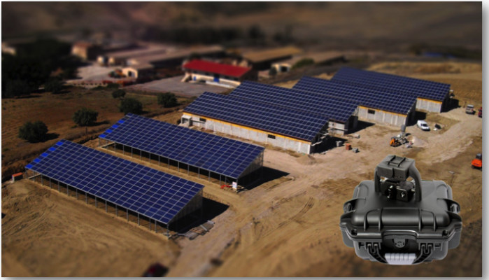
Let's take, for instance, the aerial inspection of a solar farm.
Elements in a PV plant - cells, modules, arrays - which have some troubles become overheated.
Thus the drone surely needs an eye which can observe differences in temperature to detect overheated elements (clearer in the thermography).

Furthermore, in order to clarify doubts - eg shadows - and to evidence some crack or rubbish on panels, it is better if the UAV could also observe with a second eye in the visible band.
Then it is strategic, not just to halve the time of flight, that the drone observes jointly in the thermal and visible bands and that it records what is watching in these two frequency bands.
Let's stop here for now.
What described above is a traditional system formed by a multi-copter UAV + thermal camera + video camera.
Yes just traditional: in the UAV world all things are running fast and what was born a couple of years ago is traditional by now and could be already overtaken.
Companies worldwide already use such systems for aerial surveying on solar farms: covering tens of MW in a few hours, much less than by ground. As output they deliver to their customers several hours of thermal videos which then have to be played looking for the locations of the recorded thermal anomalies.
Big solar farms are monotonous landscapes

and thus, to highlight the details of anomalies in single cells, each thermal video frame will not contain anything more than PV modules, modules, modules and modules again. And without any spatial reference - even only visual - the manual geolocation of each single frame on the whole PV field is extremely long and difficult enough to get loosing the benefit of the fast aerial survey.
Although it is strategic that the O&M technicians have quickly a final Report of the aerial survey to execute the subsequent direct checks and repairs.
And here comes the difference with a new integrated system:
mT-Panoptes, besides being a good-looking thermal+visible multi-sensor system, has a GEO heart inside which allows the automatic positioning of the detected anomalies on the survey map using flight informations (telemetries) and geographic analysis methodologies.

Do you know what this means?
Flying with mT-Panoptes and your UAV, you see in real time, on the ground base station, the drone position moving on the PV plant map and what the thermal eye observes. Moreover while flying and recording both high resolution videos on board when you note something overheated you can add a bookmark to the thermal video, by a simple click, to find quickly that frame later during the post-processing.

During the flight, the GEO heart automatically co-registers the recorded thermal and visible videos, which means that the corresponding thermal and visible frames, related to the same scene, are automatically superimposed. Thus when you stop flying, you can simultaneously play together the two videos and switch from one to another, for quickly identifying critical issues and examining them in more detail.

The GEO heart continues working also in post-processing, thus the mT-Panoptes coupled software - Solar Inspector - allows the automatic positioning on the PV plant map of those frames in which you are evidencing some anomalies and to highlight them by graphical and textual notes in a simple and fast way.

Then it fastly and automatically produces the final Report of the inspection with the INDEX MAP of the issues criticalities and detailed data sheet for each one of them.

See in the photo below the timing of surveying and production of the final Report using mT-Panoptes and compare them with the timing of reporting by traditional systems without our GEO heart:

Now that for you the mT-Panoptes with its GEO heart and the UAV surveys with geospatial capabilities are no longer something mysterious, when you will decide to acquire equipment for aerial inspections by UAVs look over, check that your system owns the GEO heart!

mT-Panoptes will be presented in USA for the first time at The Silicon Valley Drone Show in San Francisco on next April 29 - May 1 and we will illustrate the geospatial thermographic aerial inspections at the associated Conference on May, 1.
We invite the UAV manufacturers, the companies offering technical inspections by UAV, the owners and maintainers of solar farms to meet our mT-Panoptes in San Francisco.

See you there!
Chief Executive (Engg.) & Managing Partner at SUSGEN INDIA
9yinteresting....boiler, conveyor, inspection..... may be hotline inspection with due safety
Maintenance Manager in Modern Cement and Mining (MCM) - MANASEER GROUP
9yi think this device is very important for this job and also can be used for transformers inspection while in servise, it is
General manager at Rightway International Solar Power Service
9yFurther well learned how the system works, expect to have more to learn about the system.
Sales Engineer at IntelligentUAS LLC
9yVery informative, Claudia. I'm so glad that I follow you and catch every article like this.
Consultant spécialiste chez +
9yDrone Valley offre au travers du consortium d'entreprises qui la compose, le traitement des images ou dalles géoréférencées via une solution logicielle complète qui permet de rendre un rapport complet, chiffré aux clients finaux. Vous êtes opérateurs de Drones ? Contactez-nous !